Showing posts with label sea leval rise. Show all posts

Wednesday, May 23, 2012

Mangroves Lead Battle Against Rising Seas

LAE, Papua New Guinea, May 22, 2012 (IPS) - Sea level rise near Papua New Guinea, a Small Island Developing State (SIDS) in the southwest Pacific, is estimated at seven millimetres per year, double the global annual average of 2.8-3.6 mm.

In a bottom-up approach to fighting climate change, the indigenous use of mangroves is now leading local and national plans to stem the destruction of land and communities by coastal flooding and erosion.

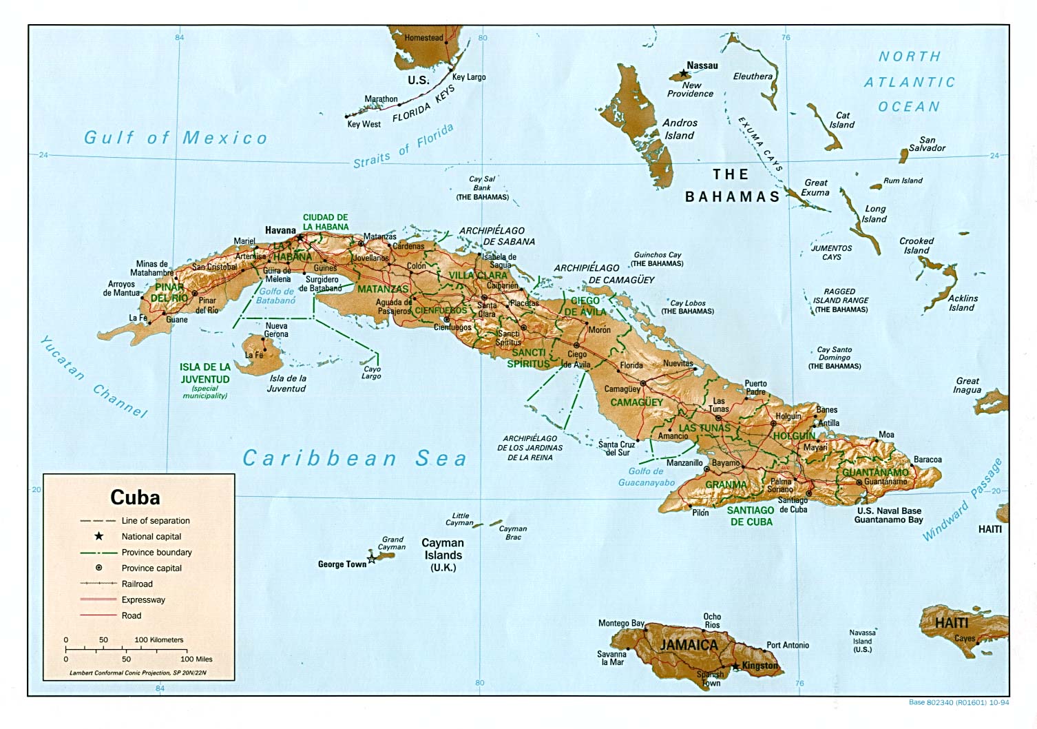
As global warming melts ice and glaciers, small island states are the first to be threatened by thermal expansion of the world’s oceans. The Pacific Climate Change Science Programme predicts that, under a high emissions scenario, Papua New Guinea could experience a sea level rise of 4-15 cm by 2030.

The government has identified coastal flooding and malaria as the two climate change hazards expected to cause the greatest damage to land, people and infrastructure. Coastal flooding has affected 8,000 people annually over the past 15 years, and could impact 65,000 people within the next 18 years. Experts say the cost of damage from coastal flooding could increase from 20 million dollars per year to 90-100 million dollars annually by 2030, but implementation of adaptation measures may reduce losses by 65-85 percent.

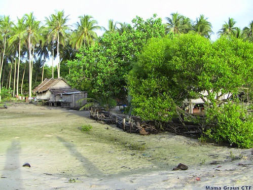
Climate adaptation is not a new concept to those who have lived along the nation’s coastlines for generations. In Milne Bay and Oro Provinces on the east coast, the Maisin, Are, Doga and Dima people of Collingwood Bay have long possessed knowledge of the importance of mangrove forests to conserve coastal ecosystems.

The waterlogged trunks and roots of mangrove trees, which grow in saltwater inter-tidal areas along rivers and between land and ocean in tropical regions, consolidate sediment, thereby strengthening coastlines and protecting against flooding and erosion.

According to Mama Graun, a local conservation trust fund, 30 of the 42 mangrove species found in Papua New Guinea grow along 159.8 kilometres of Collingwood Bay’s coastline. The tropical tree system is central to the sustainable life of villages. It provides timber for building dwellings, firewood for cooking and traditional medicinal remedies, while mangrove swamps harbour marine foods, such as fish, oysters and crabs. More


Saturday, May 19, 2012

Peabody Coal buys coal from U.S. taxpayers for cheap, sells it abroad for huge profit

Yesterday, I wrote about the issue of public land in the Powder River Basin being leased to coal companies for cheap, so they can strip-mine it and sell the coal abroad at an enormous profit.

Also yesterday, the feds held a “competitive lease sale” for the South Porcupine Tract, which contains almost 402 million tons of mineable coal.

Guess how many companies bid in this “competitive auction”? One: Peabody Coal, the company that filed the original application [PDF] for the lease.

This was actually the second auction for the tract. The first ended with no sale because BLM rejected Peabody’s lowball offer of $0.90 a ton. The winning price in Thursday’s sale? $1.11 per ton.

Again: $1.11 per ton.

The price of a ton of Powder River Basin coal on U.S. spot markets?$9.15 per ton, as of May 11.

The price of a ton of coal exported to China? It averaged $97.28 per ton [PDF] in 2011. It’s now up to $123 per ton.

And exports are only likely to go up:

So, to summarize: You, the U.S. taxpayer, just leased another huge chunk of your land to Peabody Coal at $1.11 per ton of coal. Peabody will strip-mine that land and take the coal to China, where it will sell it for over $100 per ton. Peabody pockets enormous profits*, the U.S. taxpayer gets devastated land, and China accelerates global warming. More


And for the rest of the world, specially the Small Island Developing States and coastal cities, sea level rise, flooding and eventual evacuation. Will you give us a passport President Barak Hussain Obama? Editor.

Tuesday, May 8, 2012

Sea Level Rise and Storm Surge: Nightmare Scenario for SIDS

Cambridge University glaciologist Professor Julian Dowdeswell has spent three years of his life in the polar regions.

As Director of the Scott Polar Research Institute at the University of Cambridge, this film follows him to Greenland and the Antarctic as his research reveals the challenges we all face from climate change.
credit: University of Cambridge
source: http://www.sms.cam.ac.uk/media/1100246

Tuesday, April 24, 2012

As the poles melt, we drown

At the “International Polar Year 2012 Conference” in Montreal Ronald Jumeau, Ambassador for Climate Change for the Government of the Seychelles, talked about “Poles and Global Linkages”. I want to document his remarkable presentation with this Iceblog. It shows that climate changes isn´t something abstract, but touches the lifes of many people. I thank Mr. Jumeau for allowing me to document his speech:


Ladies and Gentlemen,

Sitting here listening to the different speeches and presentations since this morning, I wonder whether I came to this conference just to be terrified.

You see, the worse the situation gets at the two poles, in the Arctic and the Antarctic, the more worried we islanders get — and the more frantic we are going to get — on the islands of the globe, including the SIDS, the small island developing states, of the tropics like Seychelles.

For the more your ice melts in the north and the south, and on the mountain tops and in the glaciers of the world, the more our world, in tiny Seychelles just 4 degrees south of the Equator and in the rest of the Indian Ocean and in the Pacific, the Atlantic and the Caribbean as well, the more our world goes under.

You see, ladies and gentlemen, as the poles melt, we drown…

And it’s not just about sea level rise being made worse and worse the more land ice melts at the poles and from the mountains and glaciers of the world and flows into the sea. Too often when people think of small islands and climate change, they think only of sea level rise…

But it is not just about that, as serious and as frightening it indeed is: the melting ice at the poles is not just contributing to sea level rise, it is affecting the oceans as drivers of the world’s climate as well. And don’t forget, while we may be the smallest countries in the world, many of us make up huge ocean territories.

So true, the seas around our islands, some of which are the lowest land on Earth, are rising, and coastal erosion is getting worse and worse to the extent that some islands may be swept away before the waves cover them and wipe them off the face of the Earth…

But it is also true that our own climate and weather, a world away from the polar regions, are changing because of what is happening to the oceans.

Let me give you an example from my own country Seychelles, where incidentally we are blowing up the granite of our mountains to get rocks to protect and save our beaches so bad is the coastal erosion. More


Wednesday, April 18, 2012

IOC Assesses Climate Vulnerability of South-West Indian Ocean Islands

13 April 2012: The Indian Ocean Commission (IOC) project on climate change adaptation, titled "Acclimate," has released five assessments of climate change vulnerability in the South-West Indian Ocean islands of the Comoros, Madagascar, Mauritius, Reunion (France) and the Seychelles.

For each case, the reports provide qualitative assessments of climate vulnerability across various sectors including: integrated water management; fisheries; risk and disaster management; energy; food security; and security and sovereignty.

According to the assessment reports, these countries face shared challenges due to climate change, such as water scarcity, extreme weather events, sea level rise and coastal erosion, and coral bleaching. The common methodological framework across all five assessments has allowed production of a regional strategy for climate change adaptation, which will be submitted for political acceptance by the concerned countries at the end of 2012.

Acclimate, which started in 2008, was commenced to strengthen the capacity of South-West Indian Ocean island States to adapt to climate change. The assessments aim to share knowledge and contribute to mainstreaming climate issues into national and regional policy processes. [Acclimate Website (in French)] [Comoros Assessment Report] [Madagascar Assessment Report] [Mauritius Assessment Report] [La Réunion (France) Assessment Report] [Seychelles Assessment Report] [Synthesis and Roadmap to a Regional Strategy for Climate Change Adaptation] [Indian Ocean Commission Website] More


Sunday, April 15, 2012

Cuba Prepares For Rising Sea Levels And Extreme Weather

Havana, April 11, 2012: One of the major challenges facing Cuba as it designs climate change adaptation policies is the preservation of its coastal ecosystems against the predicted rise in sea level and increasingly catastrophic extreme weather events.

With the country’s 5,500 km of coastline and 4,000 cays and islets, almost everyone on the Cuban archipelago feels their life is tied to the sea in one way or another. “It’s lovely, but it is also dangerous,” said 78-year-old Teresa Marcial, who lives on the coast in Santa Fé, in the northern outskirts of Havana.

For decades, Marcial has lived with the ocean practically lapping her patio. In 2005, floods caused by hurricane Wilma left her family and neighbours virtually on the street. “Huge waves swept everything away. We were taken by surprise. The water took away an extremely heavy wardrobe, which simply disappeared,” she told IPS.

Her son, Martín Pérez Marcial, added that they have decided to sell their house and move to a safer place.

“But as you can imagine, with the expectation that future hurricanes will be more intense because of climate change, no one wants to come and live here,” said a neighbour who did not mention his name.

A few blocks away, builders are constructing a house that is raised more than two metres above ground level, using part of an older house and strong pillars for support. “If there is flooding, the water can circulate freely underneath the house,” said the construction foreman, José Luis Martínez.

Behind the house, which is being built by “self help”, as private construction initiatives are called in Cuba, there is an outer wall of solid concrete and hard stone. “It saves on cement, and does not require steel, which rusts over time,” Martínez said.

The talkative builder showed how the base of the containment wall has spillways for drainage, to let water flow back and forth. At the corners, the walls are shaped like a ship’s prow, “to break up the waves.” Several houses in the vicinity have similar walls, which “cost a pretty penny,” Pérez said.

Santa Fé is at permanent risk of flooding due to hurricanes. Studies by state bodies put it among the coastal areas of the capital that face the greatest direct impact of tropical storms, and to a lesser extent of rising sea levels.

Adaptation, an inevitable necessity

Carlos Rodríguez, a researcher on land use planning and the environment for the government’s Physical Planning Institute (IPF), says 577 human settlements could suffer the combined onslaught of rising sea levels and oversized waves from swells and storm surges associated with hurricanes.

In an interview with IPS, Rodríguez emphasised that according to a joint study by several Cuban scientific institutions, led by the Ministry of Science, Technology and the Environment and including IPF, an area of 2,550 square km of coast could be submerged by 2050.

By 2100, the flooded area could expand to some 5,600 square km, according to sea level rise projections, he said. More